The Kafue basin takes up about 157,000 km2 of Zambia and contributes 8.4% to the country’s total surface water potential. The Upper Kafue River Basin (UKRB) comprises the region of the Kafue basin upstream of the Machiya Ferry Discharge station and spans across the Copperbelt and Central Provinces.
The Lukanga Swamps integrate the UKRB and span over a catchment area of 59,000 km2. One of Zambia’s key wetlands, the Lukanga Swamps develop in a shallow circular depression of a generally flat area and form the largest permanent water body of the Kafue basin.
The Upper Kafue River Basin, containing the Lukanga Swamp and its catchment is integrated in a region renowned for its copper reserves, where existing mining operations have left a legacy of mining-originated pollution. Moreover, although the current agricultural land use in the Lukanga watershed is non-intensive with limited use of fertilizers and pesticides, upstream in the Kafue river basin, there are intensive irrigation schemes that likely load nutrients into the swamp via runoff.
The main purpose of the assignment is to develop a conservation plan for the Lukanga Swamp to deal with all the impending risks and tackle all the impacts occurring now or in the future, over this ecologically relevant wetland.
The development of a conservation plan for the Lukanga Swamp requires an integrated approach focusing on both upstream and downstream interactions and on the impacts on the Lukanga Swamp and its catchment, including effects on the ecosystem services and on the livelihoods of the communities who rely on the swamp for a multitude of reasons.
Some specific tasks included in this assignment:
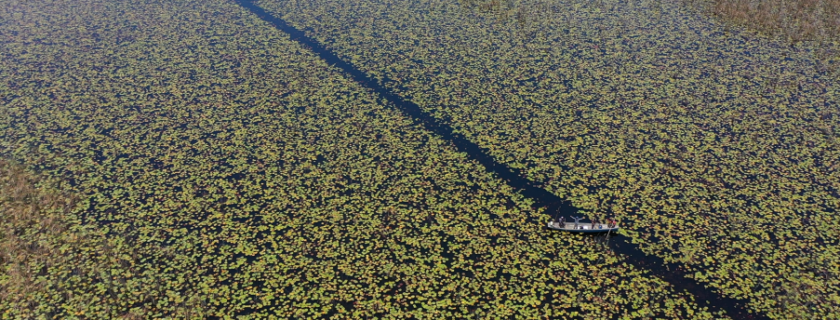
- Field work assessment of a large wetland (over 50 km diameter), mostly inaccessible using: 4×4 vehicles, wooden and fiberglass canoes, and on foot;
- Mapping of the wetland using drone footage (on site filming and photographing
- Wet and dry season sampling of simple chemicals, metals and persistent organic compounds (c. 100 sampling stations), throughout the upper Kafue river basin, and considering all the main environmental sinks: surface and groundwater, sediment, plant tissue and animal tissue.
Also:
- Definition of ecosystem types, ecosystem services, indicators and assessment methods;
- Baseline assessment of Lukanga Swamp and of possible sources of degradation upstream (in the Lukanga catchment and UKRB);
- Development of tools and recommendations for management;
Conduction of stakeholder consultation workshops, seminars and training courses.